|
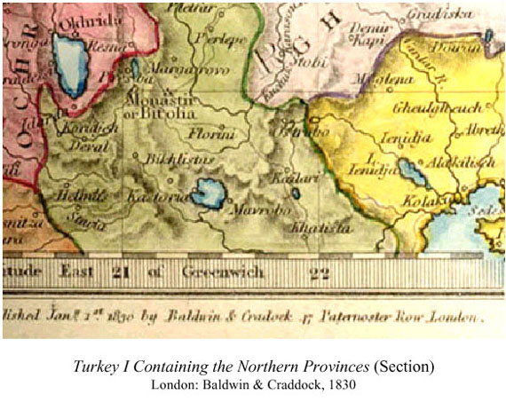
Kastoria is properly located in the map on a promontory of the western shore of the lake. The lake, however, is depicted as much larger than it is in reality. The region that holds Kastoria is colored to indicate that it is the Vilâyet of Monastir (modern Bitola). Kastoria was itself a Sanjak within the Vilâyet, and was governed by an Ottoman Kaimakam. I could not imagine any reason for Mavrovo to appear on a map of this period. It was just a village, and while large, it was but one of many that surrounded the Lake of Kastoria or survived precariously on the mountain routes tha t led out of the great basin that holds the lake. In Travels in Northern Greece, written in 1835 by William Martin.Leake, the author gives an account, in four volumes, of his early 19th century explorations in Greece. In his narrative about his visit to Kastoria he notes: “At the eastern extremity of the lake is a large village named Mávrovo.”5 Leake was a British antiquarian, a retired military officer, and an expert surveyor. His notes may have been one of the sources for the Baldwin & Craddock map. Finding the collection of maps and prints in the Argosy Bookstore irresistible, I returned two days later to continue my search through the huge portfolio files. My sense of excitement and anticipation was evidence that I had been bitten by the collector’s bug. When I came upon a map with the title EUROPÆ TABVLA IX, there was no question in my mind — I had to have it. 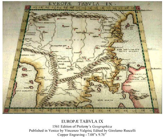 Since the original maps of the Greek mathematicia n Ptolemy (87-150 C.E.) have not survived, editions of work ascribed to him and printed between 1477 and 1730 are more than likely interpretations of the originals. This map, in addition to being aesthetically attractive, shows how inaccurate knowledge was of the exact geography of the known world at t Since the original maps of the Greek mathematicia n Ptolemy (87-150 C.E.) have not survived, editions of work ascribed to him and printed between 1477 and 1730 are more than likely interpretations of the originals. This map, in addition to being aesthetically attractive, shows how inaccurate knowledge was of the exact geography of the known world at t
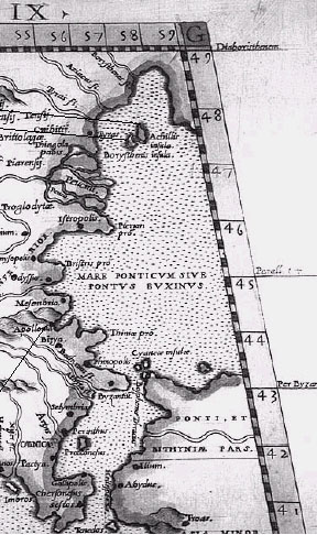
Two islands are shown to the immediate right: Achillis Borysthenis Achilles was worshipped in parts of the Black Sea. The island of Leuke (here shown as Achillis) was the site of a sanctuary. Legend has it that Achilles body was brought here by his mother, Thetis, after his death. The sanctuary was guarded by seabirds who swept it clean daily with their wings. Sozopolis is identified by its ancient name of 5 William Martin Leake, Travels in Northern Greece (London,: J. Rodwell, 1835). 6 Christos G. Zacharakis, A Catalogue of Printed Maps of Greece, 1477-1800, 2nd rev. and amplified ed. (Athens: Samourkas Foundation, 1992). 7 M. P. R. van den Broecke, Ortelius Atlas Maps : An Illustrated Guide (Netherlands: HES Publishers, 1996). Next Page: The First Historical Atlas Previous Page: Windows into the Past (Posted August 2003) For more information about the author, see his biographical sketch under the Contributing Authors' section of HCS, or visit the author's website at http://www.goldenfleecepublishing.com. Mr. Mavrovitis has written a number of fine articles for HCS which readers can browse or read at the URL http://www.helleniccomserve.com/archivemavrovitis.html. 2000 © Hellenic Communication Service, L.L.C. All Rights Reserved. http://www.HellenicComServe.com |