|
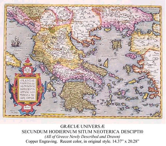
I purchased the map, a photograph of which is on the next page, and found on its back text from the Theatrum. The first paragraph, translated from the French, reads:
The text goes on to describe the sorry condition of the Greeks, and the absence of schools and lack of education for the young. Reference is made to the writings of ancient scholars: Strabo, Pausanius, etc. However the material focuses on anecdotal stories that reflect badly on the lifestyle and manners of the common Greek of the time. Maps of this period can be fanciful. This one includes a ship at sea with its sails billowing in the upper left quadrant. On some maps, ships are shown at battle, with puffs of smoke coming from broadsides. On others, there may be huge fish, even two headed whale- like creatures.
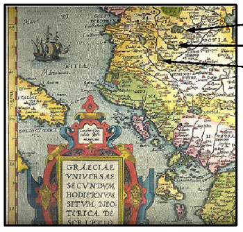
Kastoria and its lake Lake Prespa Lake Ocrida (Ochrid) Lakes Prespa and Ochrid are actually north of Kastoria and its lake, not south as shown in this map. While the written text of the Theatrum is in this edition French, the map mixes Latin and Italian in naming geographic sites. The Gulf of Corinth is, for example, named Golfo De Lepanto Classical scholarship was at the center of the Renaissance and western-European intellectual life during the 16 th and 17 th centuries. Not to be left behind, classically trained mathematicians and geographers produced maps that illustrated the world as described by Herodotus, Strabo, Pliny and Ovid. One of these, a map entitled Pontus Euxinus was published in several editions by Abraham Ortelius and his successors in Antwerp between 1590 and 1624. Pontus Euxinus was published as part of the Parergon (additional ornament ), the first historical atlas, which was initially issued as a supplement to Ortelius' world atlas, the Theatrum orbis terrarum. The maps of the Parergon illustrate the classical Greek, Roman, and Egyptian worlds, as well as the mythical past, and were the result of Ortelius' personal research. Next Page: Mapping the Argonauts Previous Page: An Incomplete Geography (Posted August 2003) For more information about the author, see his biographical sketch under the Contributing Authors' section of HCS, or visit the author's website at http://www.goldenfleecepublishing.com. Mr. Mavrovitis has written a number of fine articles for HCS which readers can browse or read at the URL http://www.helleniccomserve.com/archivemavrovitis.html. 2000 © Hellenic Communication Service, L.L.C. All Rights Reserved. http://www.HellenicComServe.com |